
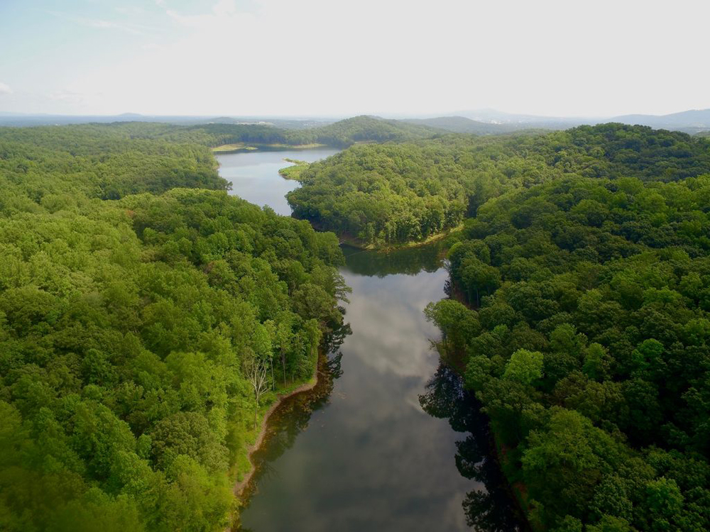
The New Ragged Mountain Dam was completed in 2014 and has won state and regional accolades for its excellence. When this reservoir is full, the useable water storage capacity is over 1.5 billion gallons. February 2016 the reservoir reached full capacity. This is a popular spot for naturalists, hikers, fishermen, and kayakers. Thanks to a collaboration between RWSA, Charlottesville City Parks and Recreation, volunteer trail builders, and Ivy Creek Foundation a floating bridge will provide a complete loop for hikers around the newly-expanded reservoir.
Click the image above for a Ragged Mountain Reservoir Information Sheet
Prior to 2014, Ragged Mountain reservoirs was comprised of two dams located in the Ragged Mountain region immediately west of Charlottesville: the Upper Ragged Mountain Reservoir and Lower Ragged Mountain Reservoir formed from an unnamed tributary to Moores Creek. The drainage area for the New Ragged Mountain reservoir is 1.8 square miles. Both swimming and motor boating is prohibited since this reservoir is part of the community raw water supply.
Awards

RWSA Receives Ragged Mountain Dam ACEC Award
On February 5, 2015 the American Council of Engineering Companies (ACECE) of Virginia presented RWSA with an Honor Award for the Ragged Mountain Dam Project.
On March 10, 2015 the Mid-Atlantic chapter of the American Public Works Association presented RWSA with an award for the Ragged Mountain Dam Project.
Among the features recognized were:
- architectural design of the new inlet/outlet tower which mimics the original structure built in 1885;
- the new auxiliary spillway, the seepage reduction control features, and the real time monitoring and rapid response features;
- and the protection of the rural charm to include the use of local timber, fish habitats, and a floating bridge for hiking trails.
History of Ragged Mountain Dam
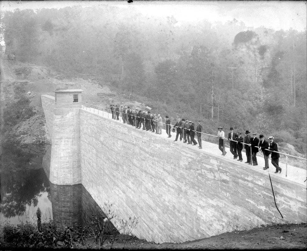
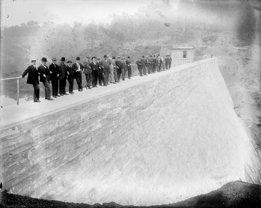
Photo of Lower Ragged Mtn Dam taken around the turn of the century by Rufus W. Holsinger (this photo resides in the UVA Special Collections Library)
The Upper Ragged Mountain Dam and Lower Ragged Mountain Dam were originally constructed in 1887 and 1908, respectively. The older of the two dams, was approximately 45 feet high and 470 feet long, consisting of earth fill and a stacked masonry core. Lower Ragged Mountain Dam was 67 feet high and 400 feet long, originally built as a monolithic cyclopean concrete dam, with an earth buttress added in 1934. Before the expansion of Ragged Mountain, the two dams received rainfall from a 1.8 square mile watershed and were capable of storing a total of 514 million gallons of water, of which 463 million gallons is considered “useable” for water supply.With the construction of the new earthen dam, the upper and lower were partially dismantled and are now underwater.
In 1978 and 1979, as part of a national dam safety inventory, the U.S. Army Corp of Engineers identified both of these dams as having an “unsafe condition” because of inadequate spillway capacity. In the mid 1980’s the original spillway on the Upper Ragged Mountain Dam was altered to improve its capacity.
In the 1990’s and early 2000’s the state and national standards for dam spillway capacity increased, requiring an even greater ability to pass storm events. Current standards require a dam, such as Ragged Mountain, to pass the Probable Maximum Precipitation (PMP) safely through the spillway.
In 2003, the Rivanna Water and Sewer Authority began engineering investigations to identify and pursue an alteration/upgrade to the Ragged Mountain Dams facility to address the outstanding dam safety concerns. In 2006, and again in 2011, City and County officials approved the pursuit of the new water supply at the Ragged Mountain Dam site. Construction of the newly expanded Ragged Mountain Dam began in 2012 and concluded in 2014. Ragged Mountain reservoir has reached capacity in February of 2016.
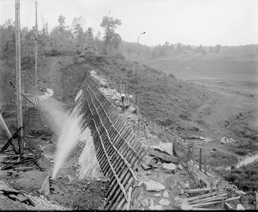
Construction of Lower Ragged Mountain Dam taken by Holsigner around the turn of the century
Men on Dam taken by Holsigner around the turn of the century
Ragged Mountain Natural Area Trails
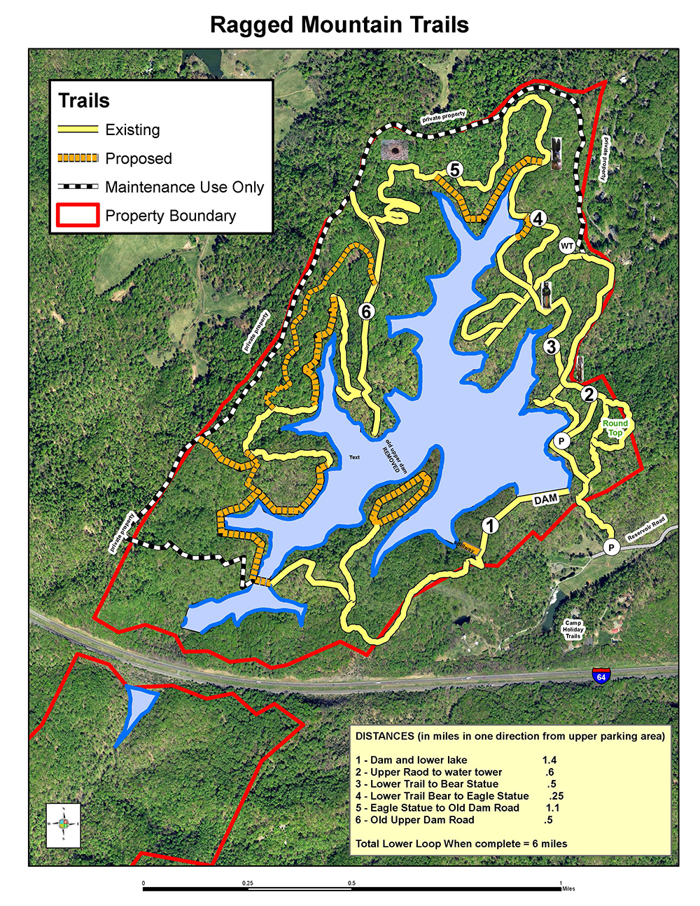
Ragged Mountain Trail Map
Rivanna and the City Parks and Recreation Department worked collaboratively during the planning and construction process on the relocation of trails that were displaced during the expansion of the reservoir. In the Spring of 2016, a floating bridge was installed by Rivanna. This bridge will provide access to the trail (shown in yellow above) around the lake for walkers, hikers, and birders. The City is currently working to complete the trail system relocation at Ragged Mountain. There is also a community discussion about whether and/or how to allow bike riding, jogging, and walking of dogs on the property in a non-disruptive manner.
In the fall 2015, City Parks and Recreation Department with the help of many local experts, undertook a “bio-blitz” and ecological survey of the entire property in order to ensure any new trails are built in locations that do not disturb unique or critical habitat or ecosystems. That process was done in concert with a planning effort to determine where the trails should go. A series of public meetings were held throughout 2016 to discuss the matter and create a plan. The plan for the trail system is slated for a City Council vote in the Spring 2017.
Components of Ragged's Earthen Dam
Schnabel Engineering, Inc. completed final design documents for the New Ragged Mountain Dam in December 2011. Prior to the final design, Schnabel considered several different types of dam construction, and selected an earthen dam as the most cost-effective approach for the geology and configuration of the site. A panel of worldwide dam experts reviewed and concurred with the decision. The new dam raised the normal reservoir pool elevation from the existing 641 feet to a proposed 671 feet (a 30 foot pool level increase). The dam was constructed to a height which allows a possible pool level increase to elevation 683 feet (an additional 12 foot increase).
There are many system components to the dam design which are necessary to safely store and convey water for use in the urban system:
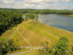
Earthen Dam Side View (taken 2016)
Earthen Dam – The dam was constructed of soils obtained from on-site borrow areas. The borrow areas are located so that they are underwater when the proposed 671 foot pool level is obtained. The dam has a sophisticated drainage system to collect, convey and monitor seepage through the dam. Ground instrumentation devices were installed sporadically on the dam surface to measure and record groundwater pressure differentials. The dam utilized approximately 595,000 cubic yards of soil. The foundation of the dam included a drilled grout curtain beneath the dam centerline. Special grout was pumped into drilled holes to fill and seal existing rock cracks and crevasses located beneath the existing ground surface. The “grout curtain” acts as a barrier to prevent excessive seepage through the ground beneath the dam structure.
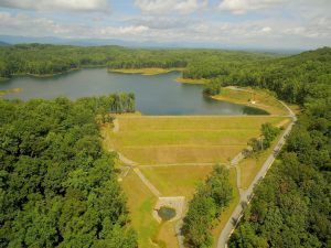
Ragged Mountain Dam Aerial Photo (2016)
Intake Riser Tower and Primary Spillway – The primary spillway tower used to control the reservoir pool level and convey normal flows during rain storm events is a 36 foot by 30 foot reinforced concrete structure. The cast in place structure rises 90 feet in height, and is exposed above the pool level 21 feet. An operations building is constructed on the top of the tower structure, and will house gate valve operators and instrumentation/control equipment pertinent to the dam operations.
Auxiliary Spillway – A rock cut auxiliary spillway was constructed to allow emergency reservoir lowering during extreme storm events. The spillway is included in the design to safeguard against dam failure in the extremely unlikely storm event of a Probable Maximum Flood as defined by the VADCR Dam Safety Division.
Intake Outfall Tunnel and Raw Water Line – In order to increase the structural integrity and longevity of the earth dam, no pipe penetrations through the dam cross section were utilized in the design. A tunnel was constructed through existing rock substrata, outside of the dam footprint. This tunnel conveys primary spillway discharges and house the 36 inch diameter raw water intake pipe which conveys water to the existing treatment facilities near the University of Virginia grounds.
Facts about Ragged Mountain Reservoir
Ragged Mtn Upper Dam built- 1887
- The original intake tower was partially dismantled and its boulders now help create the border of the parking lot and sitting stones for hikers. The new intake tower was designed to resemble the original 1885 intake structure, while providing state-of-the-art operational control.
Expanded Ragged Mountain Reservoir construction completed – 2017
- 26.9 million dollar construction budget
- 670,000 cubic yards of dirt placed
- 42,550 tons of filter sand used
- 4,400 tons of gravel used
- 2,540 feet of drainage pipe installed
- 129 feet tall
- 53 progress meetings held
- 15 regulatory permits obtained from
- 8 local, state, and federal agencies
- 3 engineering design and construction awards received
- Numerous flat tires overcome